|
Introduction
For the purposes of this report, recent sedimentation
will include that occurring during Quaternary and Holocene times.
The Quaternary period lasted from two million years ago, until about
12,000 years ago. Following the Pleistocene, the Holocene ranged
from 12,000 years ago until 1950.
Throughout this time, sedimentation in Brittany, and all around
the world, particularly the Northern Hemisphere, was dominantly
controlled by glaciations and the sea level fluctuations they induced.
At least four large-scale glacial events occurred in the Northern
Hemisphere during the Quaternary Period. Figure 1
shows the 18O/16O isotopic ratios corresponding to glacial/interglacial
periods over the past 900,000 years. The largest of these, the Anglian
Glaciation, which lasted from 500,000 to 400,000 years ago, reached
only as far south as London, England. However, these sea-level fluctuations
have left their mark on the sedimentary history of Brittany.
The discussion of recent sedimentation of Brittany is divided into
three sections. The first two of these cover sedimentation on continental
margin. The first section covers the sedimentation occuring during
regressive sea systems and the second covers transgressive sea deposits.
As will be described below, many of the deposits focused on are
eroded away each time the sea level falls during a glaciation. For
this reason, the deposits discussed in these sections will all be
from the last glacial cycle, beginning at the start of the Devensian
Glaciation, approximtely 115,000 years ago, and continuing up through
the current interglacial period. The third section will discuss
sedimentation on land.
Regressive Seas
During times of sea regression, the primary sediment
deposits occurred on the continental rise. During times of maximum
glaciation, sea level dropped significantly. At 18,000 bp, during
the last glacial maximum, global sea level was 120 meters lower
than it is today. This drop in sea level exposed the area around
the present day peninsula of Brittany, including the English Channel
and the nothern part of the Bay of Biscay. Figure 2
shows the extent of the sea at 18,000 years bp, during the last
glacial maximum. As these areas were subaerially exposed, they became
subject to fluvial erosion, as water from further onshore now crossed
the old continental shelf on its way to the sea. This water traveled
in large rivers, as does water moving towards the seas on the modern
day continents. During times of regressive or low still-stand seas,
these rivers carved large incised valleys onto what is today the
continental shelf. These incised valleys can be found in the Bay
of Biscay, and on the Armorican Margin. Figure 3 shows
the paleovalley network of the South Armorican margin. These valleys
are believed to have been initially carved out during a lowstand
sea prior to the Quaternary Period. The valleys would then have
been infilled when the sea rose again. However, because these sediments
are not compacted and lithified and are much younger than those
which make up the rest of the shelf, they are more resistant to
erosion. Thus, during the next glaciation and accompanying lowstand
sea, rivers reformed in these sediments. These new rivers carved
down through the sediments and cleared out the old valleys.
These sediments are carried away by the rivers, and eventually deposited
as marine fans on the continental rise. Fans of this type can be
seen today in the Western Approaches of the English Channel. There
is one fan, deposited by a river running from the modern day Irish
Sea, dated at seven thousand years. There are two more fans to the
south, dated at twelve thousand years, which are believed to have
originated from the Manche River, running through the modern day
channel.
These fans, and the sea floor around them include a series of turbidite
deposits. Dating of these deposits has shown an increasing number
of turbidites towards the end of the last glacial maximum. This
increase is representative of the increased terrigineous flux generated
by the Manche River. The terrigineous flux increased due to the
increased length of the river due to the low sea level, and also
to the beginning of the melt-off of the glaciers.
Transgressive Seas
During times of sea transgression, the primary sediment
deposits were on the continental shelf. Of particular interest was
infilling of incised valleys. These valleys, as mentioned above,
were carved out during regressive and low stillstand seas. They
can be found on the South Armorican margin and in the Western Approaches.
The sediments carried by rivers running though these valleys were
deposited as the river opened to the sea, and water velocity fell.
As sea level rose again at the end of each glaciation, the boundary
between river and sea moved progressively nearer the mainland and
these sediments were subsequently dropped nearer the mainland, progressively
infilling the valleys.
This infilling progressed, as would be predicited, in a sequence
of units representing depositional environments of increasing depth.
The infilling of these incised valleys is shown in Figure
4 (from Menier, 2004). The bottom sediments in the valleys
were laid down in a fluvial environment. These were deposited near
the mouth of the river, where the channel widens, and water velocity
starts to decrease. Above the fluvial deposits were estuarian deposits.
These sediments were laid down in an estuary environment. At this
time, the sea level had risen to just above the depositional area
and the setting would be similar to marine estuaries found around
the world today. Above the estuarian deposits are open marine deposits
as sands. Once sea level rose high enough, the channel would be
at the sea floor, as it is today. Above the sand shallow deposits,
bay deposits (clay) have been found. These deposits fill in the
top of the valleys and are continuous across the shelf surrounding
the valleys. The progressive return to distal deposits suggests
a complete transgressive sequence with a continuous increase in
global sea level since the last glacial maximum, 18,000 years ago.
In the English Channel and its western approaches, the infilling
is made of muds deposits covered by progressive sands marine deposits.
These deposits belong to the Little Sole formation (Pleistocene).
These depositional environments have been determined through careful
study of both sediment cores and seismic surveys. Figure
5 shows a seismic survey through one of these infilled
incised valleys of the South Armorican margin. The figure shows
the original deep valley, and subsequent sedimentary units, which
are remains of old infillings, which were only partially carved
out during later lowstand sea periods.
Also found in the western approaches of the English Channel are
a series of sand dunes (Melville formation.). Like the fans and
turbidites, many believe these dunes to have been deposited during
the last regressive system and are composed of sediments carried
to the edge of the continental shelf by paleorivers, many flowing
through the incised valleys discussed above. However, others claim
that there is no clear unconfomity between these dunes and the infilled
valleys, and thus the dunes were deposited during the transgressive
system.
Land Deposits
Onland quaternary deposits rarely show succession
of glacial cycles but they are consistent with the sea level fluctuations.
In general, glacial type deposits are peri-glacial one: eolian silts
(loess) wich mainly come from the channel erosion. The eolian deposits
are thinner from the north coast of brittany to the south and they
are always on the northern slope of valleys (example of the Noth
coast of Plougastel peninsula). Heads deposits are also related
in many places and one of them was observed on Groix island (Figure
6). These deposits are intercalated with interglacial deposits
wich show various changes of the global temperature and the sea-level
fluctuations: beaches and sand dunes, podzols floors wich sometimes
recover these dunes or peat deposits (lacustrines).
_________________________________
Summary
The recent sedimentary evolution of Brittany has
been heavily dependent on transgressive and regressive sea cycles
corresponding to a series of Northern Hemisphere glaciations during
the Quaternary Period. The last of these glaciations ended at the
end of the Quaternary, and the whole of the Holocene was during
a transgressive system associated with the beginning of the last
interglacial time. The majority of recent continental margin deposits
are no older than the last glacial maximum, 18,000 year ago. At
this time, low sea levels allowed flowing rivers to erode away almost
all sediment deposits from previous transgressions. Regressive seas
led to deposits of submarine fans and turbidites on the continental
rise. Transgressive seas led to infilling of incised valleys.
On land, the last 2 million years has been primarily an erosive
time in Brittany, though some deposition has occurred such as eolian
loess and peri-glacial head during glacial times and littoral sands
dunes and lacustrine deposits during interglacial times.
|
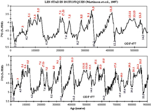 Figure
1 : 18O/16O isotopic ratios corresponding
to glacial/interglacial periods.
Figure
1 : 18O/16O isotopic ratios corresponding
to glacial/interglacial periods.
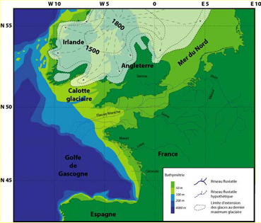
Figure
2: Extent of the sea at 18,000 years bp, during the last
glacial maximum (Menier, 2004).

Figure
3 : Paleovalley network of the South Armorican margin (Menier,
2004).
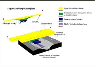
Figure
4 : Depositional sequence of valley infilling on South
Armorican margin (Menier, 2004).
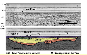
Figure 5: Seismic image (Sparker source) of the infilling
of a paleovalley from the South Armorican margin (Menier, 2004).
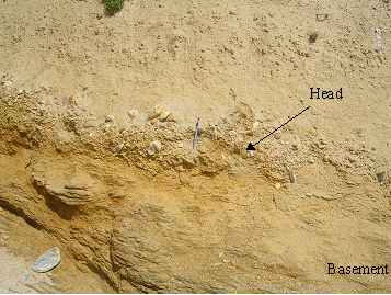
Figure 6: On-land head deposit from south of Groix
Island. Pen for scale.
|