|
Introduction
The Earth is composed of several plates
that move in various directions on the lithosphere (Figure
1). When these plates collide with one another it is called
convergence. Convergent boundaries are regions that have maximum
shortening and have the highest shear motion on the surface, which
produces large earthquakes. When there is convergence of two plates
a process called subduction occurs. There are four types of convergence
between plates: oceanic-oceanic, oceanic-continental, oceanic-continental
along island arcs, and continental-continental.
1. Subduction process
Oceanic-Oceanic
When two oceanic plates collide (Figure 2), the
younger of the two plates will ride over the edge of the older plate.
The younger plate is less dense than the old, cold one.
The older, heavier plate bends and plunges steeply through the athenosphere.
As it is descending into the earth it heats up due to the friction
and the oceanic plate starts to melt forming magma. This magma is
now less dense then the surrounding rock and it pushes its way up
through the crust and forms a chain of volcanoes. These generally
volcanoes form in a semi-circular pattern called an island arc.
An example of an island arc is the Aleutian islands of Alaska.
Subductions of plates cause oceanic trenches. When two oceanic plates
collide they form a trench in the area where one plate is being
subducted. The Marianas Trench is an example of an oceanic trench.
It plunges deeper into the Earth's interior (nearly 11,000 m) than
Mount Everest. Volcanic island arcs closely parallel trenches. The
trenches are the key to understanding how island arcs such as the
Marianas and the Aleutian Islands have formed and why they experience
numerous strong earthquakes.
Oceanic-Continental
When an oceanic plate converges with a continental plate (Figure
3), the oceanic plates is pushed beneath the continental
plate. Oceanic plates are denser than continental plates, so the
continental plate rides above. As the oceanic plate moves down into
the Asthenosphere it heats up and begins to melt. This magma begins
to push its way up to the surface and form volcanoes called a Volcanic
Arc.
The continental crust that rides over the subduction area experiences
deformation. The subducted oceanic crust compresses and pushes up
on the continental crust. This process folds the rock producing
mountains. An example of an oceanic-continental convergence and
subduction is the Appalachian Mountains along the eastern North
America.
Oceanic-Continental along
Island Arcs
When two oceanic plates collide, they form a chain of islands called
island arcs. These islands continue to move with the plate they
lie on. Over time these oceanic plates they lie on will come in
contact with either another oceanic plate or a continental plate.
When they become in contact with a continental plate and subduction
starts to occur they do not go down with the oceanic plate they
lie on. They are less dense that the oceanic plates so they attach
to the continent they collided with. This is very common along the
western coast of North America. Most of the terrain is foreign,
meaning it was not initially there. It was once part of an island
arc that is now cemented to the North America plate. This process
is called continental accretion.
Continental-Continental
In continental-continental collisions (Figure 4),
neither plate subducts because the continental rocks are relatively
light and resist downward motion. Instead, the crust tends to buckle
and be pushed upward or sideways. The convergent zone becomes a
site of intense mountain building (thrust or reverse faults, folds,
metamorphism, etc.). Currently, this can be seen in the Himalayas
where India is crashing into Asia.
Subduction Zones
Subduction zones are associated with the deepest earthquakes on
the planet. Nearly 80% of the total seismic energy released is in
subduction zones. Earthquakes are generally restricted to the shallow,
brittle parts of the crust, generally at depths of less than 20
km. However, in subduction zones, earthquakes occur at depths as
great as 700 km. These earthquakes define inclined zones of seismicity
known as Wadati-Benioff zones, which outline the descending lithosphere.
2. Examples of present subduction
An interesting subduction zone is along the Casades in
the northwestern United States and Canada (Figure 5).
Here the Juan de Fuca plate is being subducted under the North American
plate. The Juan de Fuca plate is relatiely young only ten million
years old and has a low density so it is concluded that this should
be a very active area in terms of earthquakes. However, the opposite
is occuring. There are no recent earthquakes.
The Juan de Fuca plate is moving in a northwestern direction into
the North American plate. The subduction is at a steep angle and
is forming a very large accretionary wedge due to this steep angle.
However, the Casade Mountains serve as a backstop to the wedge.
The backstop is composed of accreted terranes, which are basalts
and volcanic rock.
The subducted plate is divided into
three areas of movement occuring: locked, transition, and slipping
(Figure 6). The area that is considered to be locked
is below the accretionary wedge. This area is determined to be locked
due to the low temperatures. The temperatures range between 100-150
degrees Celsius. This area is experiencing the most strain. The
transition area is located below the backstop, this is between the
locked and slipping areas. So it experiences both extremes. Further
down the subduction is where slipping is occuring. This is the area
of intense heat, which might explain why it slips easier than the
area further up subduction. This intense heat begins to melt the
plate and that is why you see a volcanic arc located above. An earthquake
would occur when the tension in the locked area when it has surpassed
its limit.
Cores have been taken from the Casadian basin and a regular turbiditic
cycle was found every 700 years. It is believed that these cycles
are caused by earthquakes. There have also been effects on land
in this region that indicate earthquakes have in fact occurred in
this subduction zone and from cycles it looks like we are in store
for another earthquake in this region.
Another area of interest that has increased the
effort to understand subduction and possible zones of hazard is
the recent Sumatra Earthquake/Tsunami. The earthquake was recorded
to be a magnitude 9.3. The devastating megathrust earthquake of
December 26th, 2004 occurred on the interface of the India and Burma
plates and was caused by the release of stresses that develop as
the India plate subducts beneath the overriding Burma plate. The
India plate begins its descent into the mantle at the Sunda trench
which lies to the west of the earthquake's epicenter.
One indicator of a large earthquake is the rupture area. The Sumatra
Earthquake’s rupture area was 1200 km by 100 km, which is
about the the same area of the Gulf side of Florida. When an area
experiences an earthquake along a subduction zone the stresses that
had been built up are released. However, when there is movement
along an area of a subduction zone the rest of the zone must react.
So aftershocks occur along the subduction zone to try to equilibrate
the zone again. Aftershocks tend to propogate away from the epicenter.
3. An example of past subduction
There is a schematic cross-section through the island of Groix (Figure
7) that separates the island into two units. The first
unit is located on the western half of the island and it is an anticline.
The main rocks of this area are composed of green shales and micaschistes
with traces of graphite, indicating a weak metamorphism. The second
unit is located on the eastern half of the island, and this unit
is superior to the previous. The presence of blue shales and micaschistes
with garnets indicates a more elevated metamorphism. One wonders
why the unit the with lower métamorphism is located in the
anticline, and the unit the more métamorphism in the syncline.
Two hypotheses exist:
- The first is that the floor that was being subducted broke off
and a piece went back up.
- The second is more of a tectonic phenomenon: the plate went back
up on a rail with obduction. Even though it is not possible to opt
for one or the other of these hypotheses on this day, we decide
to describe the second more precisely. At the time of subduction
the oceanic crust went under the Armorican microplate, a prism of
accrétion formed itself in the front of this continent, by
the accumulation of sediments coming from the erosion (Figure
8).
The subduction continues under this prism
for a major part of the oceanic crust, but a part is detached and
goes back up over it by the phenomenon of obduction (Figure
9).
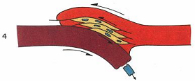
While the continental sedimentation continues,
the oceanic crust obductée is dismantled. The new prism is
a mixture of continental materials and oceanic materials (Figure
10).
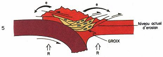
As the subduction continues, the oceanic floor
disappears completely under the continent, and the two plates collide.
The Aquitania microplate passes under the Armorica microplate, burying
the prism of accrétion and undergoes intense temperature
and pressure (Figure 11).
The continental crust is thickened by the
overlaps and begins the formation of a mountain chain. This chain
of mountain immediately starts to erode. The isostatic compensation
drives to the vertical ascent of the mixture, bringing closer it
of the surface (Figure 12). The rocks present in
these outcrops have been formed 400 millions years ago.
Conclusions
The subduction is a complex phenomenon present
in the different ages of the Earth. Different types of subduction
exist. It is possible to describe from the present observations
of the past subductions.
|
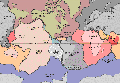
Figure
1 : This is a map of the plates around the world (internet).
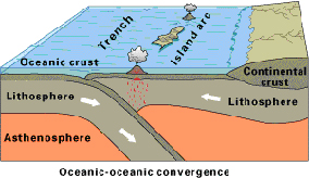
Figure
2: This illustrates the collision between two oceanic plates
and the movement of the plates (internet).
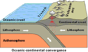
Figure
3 : This is an illustration of how the plates move in an
oceanic-continental convergence (internet).
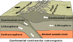
Figure
4: This is an illustration of what occurs when two continental
plates collide (internet).
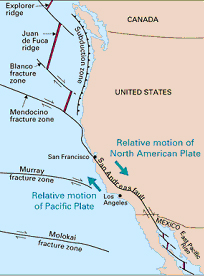
Figure 5: This picture shows area of the subduction zone
(internet).
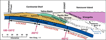
Figure 6: This picture shows the three areas of the subducted
plate (Hyndman & Wang, 1993; Hyndman & Lewis,
1995).
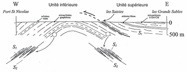
Figure 7: Schematic cross section of the island of Groix
(livret guide).
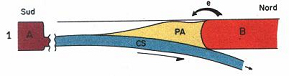
Figure 8: : Stage 1 (Audren, 1986)
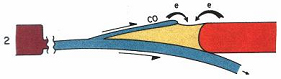
Figure 9: : Stage 2 (Audren, 1986)
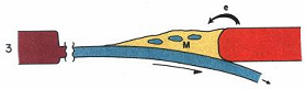
Figure 10: : Stage 3 (Audren, 1986)
Figure
11: : Stage 4 (Audren, 1986)
Figure
12: : Stage 5 (Audren, 1986)
Web
site reference
http://geology.er.usgs.gov/eastern/plates.html
and associated links |