|
1.
Introduction
Since 1982, a part of the island of a surface of
47 hectares is protected. It is called the Réserve naturelle
François Le Bail. This reserve finds its geological interest
around the tip of the Cats, preserving a witness exceptional of
the geological history of Brittany.
After our crossing of Lorient in Groix, and our landing on the island
in Port-Tudy (Figure 1), while respecting this
unique place, we start our itinerary that will make us border the
coasts East and Southeast of the island.
Our first outcrops spread from Port-Mélite to the tip of
the Cats, while passing by the Plage des Grands Sables. Then we
will observe the rocks of the réserve naturelle of the South
of the island, and the remarkable folds in sheats.
2.
Metamorphism
Many mineralogical assemblies are present on this
island. In Port-Mélite, we distinguish two types of metamorphic
rocks that differ in their origin.
The metamorphic sediments are composed of quartz, plagioclases,
albite, white micaschistes (muscovite or phengite according to the
pressure). These rocks don't possess a biotite, the present black
minerals are chloritoïdes. They often contain some garnets.
The origin of the sediments is the continent.
The metamorphic volcanic rocks are constituted of different amphibolites,
chlorite, albite, épidote and garnets. The origin of the
volcanism is the volcanos of bows (tuffite). These mineralogical
associations indicate a retrometamorphism (decrease of the temperature
and pressure). The ghosts of minerals of present lowsonite in some
rocks are relics of the path prograde. This metamorphism dates the
middle and superior Devonien.
The absence of granite on the island and on the other hand the presence
of blue schists indicates a metamorphism of high pressure and low
temperature. It is possible to find an alternation of beds of former
sediments and basic level, evidencing the volcano-sedimentary activity.
The eclogite to glaucophane assemblage in the reserve indicates
a metamorphism of high pressure and low temperature. The association
of chlorite with the albite is the evidence for a retrograde metamorphism,
the presence of water being necessary.
According to the distribution of the minerals on the island, it
is possible to draw a map of the zonation of the metamorphism (booklet
guides). The metamorphism is more intense in the syncline, to the
East of Groix. One can think that the oceanic floor has been cut
and that a part went back up to the surface. Another hypothesis
implies a tectonic phenomena (subduction and obduction).
4.
Strain pattern
The shearing in surface of the rocks
is North South. The present minerals, as the chloritoides, are lengthened
in the same direction. The planes C and S are superimposed, the
rate of shearing is raised therefore. Some lenses sigmoïdal
draws themselves by the apparition of the plane C.'
The presence of boudinage indicates a succession of compression
and extension. The foliation is here subhorizontal.
Remarkable sheathlike folds (Figure 2) are located
at the level of the small valley of Kerigant. These folds are visible
in the layers of quartz wrapped in the micaschiste (Figure
3). |
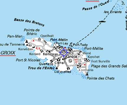
Figure 1. Map of Groix island (internet)
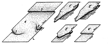
Figure 2. Different stages of development of the sheathlike
folds (Quinquis, 1980).

Figure 3. folds visible in the layers of quartz wrapped
in the micaschiste.
3.
Subduction, obduction
See Part 3 of Webpage on Subduction
The floor of the ocean situated between the Aquitania plate and
the Armorica plate disappears under this plate by the phenomenon
of subduction. The sediments coming from the erosion of the Armarica
plate are accumulated forward of the continent forming a prism of
accretion.
A fragment of the oceanic floor is detached such a chip, and carried
on the prism of accretion. This process is named obduction.
The continental sedimentation continues and cover the fragments
of floor oceanic obducted. The prism is then a mixture of oceanic
and continental materials.
Aquitania and Armorica enter in collision after the total disappearance
of the oceanic floor. The overlaps thicken the continental crust.
There is formation of a mountain belt. The "mixture" at
depth undergoes an increase of temperature and pressure. The belt
is immediately submitted to erosion, resulting in a permanent mass
decrease. By isostatic balance, it goes back up to the vertical.
The minerals bury previously goes back up to the surface.
5.
Conclusion
With its different particularities, as its convex beach, and its
changing "decor", this beach migrates, it is always a
pleasure to get around Groix. Besides its geological treasures,
it gives promises of new discoveries during every excursion. This
day in addition to be instructive was therefore very pleasant. |
