|
The MOBAL'03 Transect
Reports
|
PICS 2001-2003: Project - Results 2002
in French
|
|
MOBAL: Facts 2003 - pdf (in French)
|
|
NATO
LG 1997-98: Report (in English)
|
|
NATO
CLG 2001-02: Report (in English)
|
|
MAIN RESULTS FROM THE MOBAL'03 EXPERIMENT
|
|
MORDVINOVA V.V., DESCHAMPS A., DUGARMAA T., DEVERCHERE J.,
ULZIIBAT M., SANKOV V.A., ARTEMIEV, & PERROT J.
Velocity structure of the lithosphere
on the 2003 Mongolian-Baikal transect
from SV waves
Izvestiya Phys. Solid Earth, 43 (2), 119-129, ISSN 1069-3513, 2007.
|
|
MORDVINOVA V.V., DESCHAMPS A., DUGARMAA T., DEVERCHERE J.,
ULZIIBAT M., SANKOV V.A., ARTEMIEV, & PERROT J.
Velocity structure of the lithosphere
on the 2003 Mongolian-Baikal transect
from SV waves
Izvestiya Phys. Solid Earth, 43 (2), 119-129, ISSN 1069-3513, 2007.
|
|
BARRUOL G. , DESCHAMPS A.,
DEVERCHERE J., MORDVINOVA V.V., ULZIIBAT M., PERROT J. ARTEMIEV A.A.,
DUGARMAA T., & BOKELMANN G.
Upper mantle
flow beneath and around
the Hangay dome,
central Mongolia
Earth Planet.
Sci. Lett., 2008
|
|
TIBERI C., DESCHAMPS A., DEVERCHERE
J., PETIT C., PERROT J., APPRIOU D., MORDVINOVA V.V., DUGARMAA T., ULZIIBAT
M., & ARTEMIEV A.A.
Asthenospheric imprints
on the lithosphere in Centra Mongolia
and southern Siberia from a joint inversion of gravity
and seismology (MOBAL experiment)
Geophys. J. Int., 2008.
|
|
Petit, C., C. Tiberi, A. Deschamps,
and J. Deverchere
Teleseismic traveltimes, topography and the lithospheric
structure across western Mongolia
Geophys. Res. Lett., doi:10.1029/2008GL033993, 2008
|
|
MUNKHUU
Ulziibat
The 2003 Chuya sequence (North Altay range): tectonic context and seismological study
PhD Thesis, Nice University,
France, 2006
|
|
MoBaL is
the acronym for "Mongolian-Baikal Lithosphere seismological Transect". This work was led
in the framework of the French CNRS Research Program called PICS
("Programme International de Coopération Scientifique") entitled "Déformations actives et
structures lithosphériques en domaine intra continental : étude intégrée du
système Mongolie-Baïkal". It implies a collaboration between
CNRS in France, Academy of Sciences in Russia (Siberian Branch of the
RAS) and Academy of Sciences in Mongolia.
Year 1
(2001) was dedicated to paleoseismology under the
direction by Jeff RITZ.
Year 2 (2002) was dedicated to GPS geodesy under the direction by Eric CALAIS.
Year 3 (2003) was dedicated to the MOBAL experiment under the direction
by Anne DESCHAMPS.
General coordination was made by Jacques DEVERCHERE.
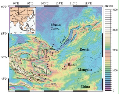
The
2003 MOBAL Experiment aimed
at imaging the crustal and upper
mantle structure from the
Siberian platform in the north to the Gobi-Altay range
in the south, in order to
provide geodynamic constraints to deep lithosphere and asthenosphere velocities and deformations,
and their relations to the Siberian
craton, the Baikal rift, the Hangay
dome and the large scale strike-slip faults of Sayan, Bolnay and Bogd. Several observations suggest a hot upper mantle beneath central Mongolia likely associated to a lithosphere thinning, that may also explain
the anomalous elevation associated to the Hangay dome.
The
MOBAL experiment was divided into 3 phases:
- Prospecting for the definition
and location of the seismic network : work done in summers 2001 and 2002.
- Installation and operation of 18 seismic stations (French instrumentation) in 2003 (April to October).
- Distribution of data, processing and interpretation (from November 2003 until now).
The
main participants were : Anne Deschamps :
Géosciences Azur, CNRS, Nice, France. Jacques Déverchère,
Julie Perrot : Domaines Océaniques, UBO/CNRS, Brest, France. Valentina Mordvinova, Alexandre Artemiev,
Institute of the Earth Crust,
Irkustk, Siberia. T. Dugarmaa, M. Ulziibat, Urtnassan, RCAG, Ulan Bator, Mongolia.
The
period of observation was
chosen from 25 April to
15 October 2003 to have the longer observation
duration and avoid winter
problems at the stations.
Field experiment
Sites
have been recognized and prepared
in 2002 (see report).
The main instrumentation involved is the following:
A. Siberia:
-
Sensors : 1 CMG3ESP, 1 STS2, 1 CMG3T (all with a similar response at 120 sec) 3 CMG40 (response
at 40 sec)
- Digitisers : 6 titan3XT/minititan3XT, with titan GPS for time, which will be installed
and on continuous power.
- Spare digitizer 14 hard
disks for titan3XT or minititan3XT
- 7 battery chargers 2
laptop for maintenance (dos)
- 1 PC for data storage (+CDROM writer)
(windows)
- 1 PC for data processing
B. Mongolia:
-
Sensors : 4 STS2, 1 CMG3T (all with
a similar response at 120
sec) 7 CMG40 (response at 40 sec)
- Digitisers : 4 titan6NT (see
photos) 4 titan3XT (see photos) 4 minititan3XT (as
titan3XT), all with GPS time
- 13 hard disks for titan6NT
- 17 hard disks for titan3XT or minititan3XT
- Solar panels (2 per station)
- 2 laptop for maintenance (dos)
- 1 PC for data storage (+CDROM writer)
(windows)
- 1 PC for data processing
The
location of the network was defined
and sites have been prospected in summer 2002: 6 sites are in Siberia,
12 sites in Mongolia.
2
visits have been done to
the instruments during the recording
period. This work was taken in charge by Mongolian and Siberian colleagues. A visit consists mainly to test how the
recorder is working,
change the disk and write
on the visit page all information necessary for the understanding
of the data recorded.
The
data set is available on
the data delivery Center RESIF.
|